Summary
- Sudden downpour triggers flash floods and paralyzing traffic across Delhi and Gurugram.
- Weather stations log up to 60 mm of rainfall in three hours, prompting IMD to escalate to a “Red” alert.
- No advance warning issued earlier in the day, raising concerns over real-time forecasting failures.
Unseasonal Fury: Delhi’s Downpour Disaster
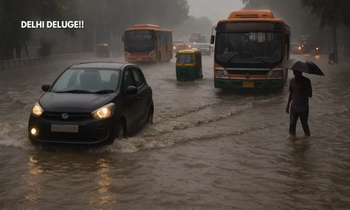
What began as a routine monsoon afternoon on July 9 turned into a disruptive deluge by evening, as Delhi and parts of the National Capital Region (NCR) were hit by intense, localized rainfall. While Safdarjung—Delhi’s primary observatory—recorded a mere 1.4 mm, areas like Najafgarh logged a staggering 60 mm between 5:30 pm and 8:30 pm. The spatial disparity in rainfall combined with inadequate stormwater management led to severe waterlogging, leaving key roads and intersections submerged.
The Indian Meteorological Department (IMD) initially failed to predict the downpour, issuing no warning until late afternoon. By then, traffic was already in disarray, prompting an “orange” alert, which was later upgraded to “red.” The late warning and uneven distribution of rain exposed a familiar gap in India’s real-time weather readiness—even as public frustration grew.
#InPics | Severe waterlogging grips several parts of Delhi NCR, as heavy rain lashes the national capital, triggering major traffic disruptions and flooding key low-lying areas. #Rainfall #WaterLogging #DelhiRains #Delhi #delhincr #waterlogged #newdelhi #Gurugram #noidarains… pic.twitter.com/fxfrDjez2j
— Business Standard (@bsindia) July 10, 2025
Gurugram, Kailash Colony, Nehru Place: Urban Flooding Returns
- Waterlogged roads reported from Aurobindo Marg, ITO, Chirag Delhi, NH-8, and more.
- Commuters stranded in cars, autos submerged, and Metro access points flooded.
- Netizens vent online, sharing visuals of knee-deep water and blocked traffic signals.
By 6:30 pm, visual evidence of flooding poured in from South Delhi and Gurugram. From Kailash Colony’s sunken intersections to MG Road’s submerged service lanes, the infrastructure collapse was visible. Areas like Pragati Maidan (37 mm), Aya Nagar (50.5 mm), and Pusa (30 mm) saw sustained downpours that outpaced urban drainage systems.
The traffic police struggled to manage clogged intersections, while residents used social media platforms to crowdsource safer routes. MNC office-goers in Gurugram faced hour-long gridlocks, prompting a relook at emergency evacuation plans in NCR’s commercial zones.
Monsoon Forecasting Under Fire
- No rain alert until afternoon; IMD’s “red” warning came post facto.
- IMD expects continued moderate to intense showers over next 48 hours.
- Urban disaster readiness under scrutiny as climate volatility surges.
The storm caught both authorities and citizens off guard, despite the IMD’s high-tech forecasting systems. Critics pointed out that the Safdarjung station’s minimal reading misrepresented the actual severity of the weather across the NCR. Meanwhile, the rise in Yamuna’s water level following upstream rainfall in Prayagraj prompted a fresh flood alert for Delhi.
Wednesday’s rainfall was accompanied by high humidity (81%) and a slight dip in temperature—maximum settling at 34°C and minimum at 26.4°C. The IMD also predicted continued rainfall, thunderstorm activity, and lightning over the next two days.
A Capital Choked: Infrastructure Questions That Refuse to Go Away
Despite repeated instances of waterlogging over the past five years, Delhi-NCR’s urban resilience appears stagnant. The failure to act on drainage audits and real-time waterlogging maps has made the monsoon a perennial governance crisis. The mismatch between rainfall data, alert systems, and ground preparedness is now at the center of public outrage.
While municipal agencies like MCD and Gurugram’s civic bodies claim desilting work was completed in May, the rain revealed otherwise. With just 60 mm of rainfall bringing NCR to its knees, the question remains: what happens when cloudbursts and climate anomalies scale up?


