
Key Highlights:
- Powerful 5.8 magnitude Assam earthquake jolt struck Udalguri district at 4:41 PM on September 14, 2025, with tremors felt across Northeast India, North Bengal, and Bhutan
- No casualties or major property damage reported despite widespread panic as residents rushed outdoors following the intense seismic event
- Two aftershocks of magnitude 3.1 and 2.9 recorded following the main tremor, with more expected in similar range
Opening Overview
A significant 5.8 magnitude Assam earthquake jolt shook the northeastern state on September 14, 2025, at precisely 4:41 PM IST, sending tremors rippling across vast regions of Northeast India, North Bengal, and neighboring Bhutan. The powerful seismic event, centered in Udalguri district at coordinates 26.78°N and 92.33°E with a shallow depth of 5 kilometers, triggered widespread panic as terrified residents rushed out of buildings across Guwahati and surrounding areas.
EQ of M: 5.8, On: 14/09/2025 16:41:50 IST, Lat: 26.78 N, Long: 92.33 E, Depth: 5 Km, Location: Udalguri, Assam.
— National Center for Seismology (@NCS_Earthquake) September 14, 2025
For more information Download the BhooKamp App https://t.co/5gCOtjdtw0 @DrJitendraSingh @OfficeOfDrJS @Ravi_MoES @Dr_Mishra1966 @ndmaindia pic.twitter.com/fGgMfM05Lb
This latest Assam earthquake jolt underscores the region’s position as one of the world’s most seismically active zones, classified under India’s highest-risk Zone V by the Bureau of Indian Standards. The National Center for Seismology confirmed that the seismic event occurred near the Kopili Fault system, close to the location of the April 2021 magnitude 6.4 Sonitpur earthquake, indicating ongoing tectonic stress in this geologically volatile region.
Seismic Impact and Regional Response
- Maximum intensity VI recorded on Modified Mercalli scale within 5 km of epicenter during the tremor
- Over 20 broadband seismic stations recorded the Assam earthquake jolt, demonstrating extensive monitoring network coverage
The seismic event generated intensity readings ranging from II to VI on the Modified Mercalli Intensity scale, with the strongest shaking occurring within a 5-kilometer radius of the Udalguri epicenter and measurable tremors extending up to 500 kilometers from the source. Chief Minister Himanta Biswa Sarma promptly addressed public concerns following the Assam earthquake jolt, confirming through social media that “there has been no report of any major damage or loss of life” while assuring citizens that his administration was “actively monitoring the situation”.
Major earthquake in Assam. My prayers for everyone's safety and well-being.
— Sarbananda Sonowal (@sarbanandsonwal) September 14, 2025
Urge all to stay alert! #Earthquake
The tremor prompted immediate responses from disaster management teams across affected states, with officials in Arunachal Pradesh and Manipur confirming no structural damage or casualties despite widespread public alarm. Former Assam Chief Minister and current Union Minister Sarbananda Sonowal urged citizens to “stay alert” following the Assam earthquake jolt, posting prayers for everyone’s safety and well-being on social media platforms. The earthquake’s shallow depth of 5 kilometers amplified ground shaking intensity, explaining why the seismic event was so widely felt despite its moderate magnitude.
Geological Context and Seismic Classification
- Northeast India classified as Seismic Zone V, the highest risk category where earthquake jolts of magnitude 7+ are expected
- Region experiences 743 earthquakes of magnitude 4+ within 300 km radius over past decade, averaging one significant tremor every 5 days
The Assam earthquake jolt occurred within India’s most seismically dangerous Zone V classification, where the entire northeastern region faces the highest earthquake risk due to complex tectonic interactions between the Indian and Eurasian plates. According to the National Center for Seismology, the tremor originated near the Kopili Fault system, one of several major geological structures including the Himalayan Frontal Thrust, Main Boundary Thrust, and Main Central Thrust that contribute to the region’s intense seismic activity. Statistical analysis reveals that within a 300-kilometer radius of Assam, 743 earthquakes of magnitude 4 or greater have occurred over the past decade, demonstrating the extraordinary frequency of seismic jolts in this earthquake-prone region.
An earthquake struck Guwahati today. Sharing a glimpse from my residence — this flower tub alone is enough to show how powerful the tremors were. pic.twitter.com/fAviob2tzz
— Bhupen kumar Borah (@BhupenKBorah) September 14, 2025
The Bureau of Indian Standards classification places the entire Northeast, including the recent Assam earthquake jolt zone, in the category expecting Modified Mercalli intensities of IX or higher, with peak ground acceleration values ranging from 0.24g to 0.48g. Historical records document devastating earthquake jolts in the region, including the 1897 magnitude 8.1 Shillong earthquake and the 1950 magnitude 8.6 Assam-Tibet earthquake, establishing a pattern of major seismic events that contextualizes the current Assam earthquake jolt.
| Major Historical Earthquake Jolts in Northeast India |
|---|
| Year |
| 1897 |
| 1950 |
| 2021 |
| 2025 |
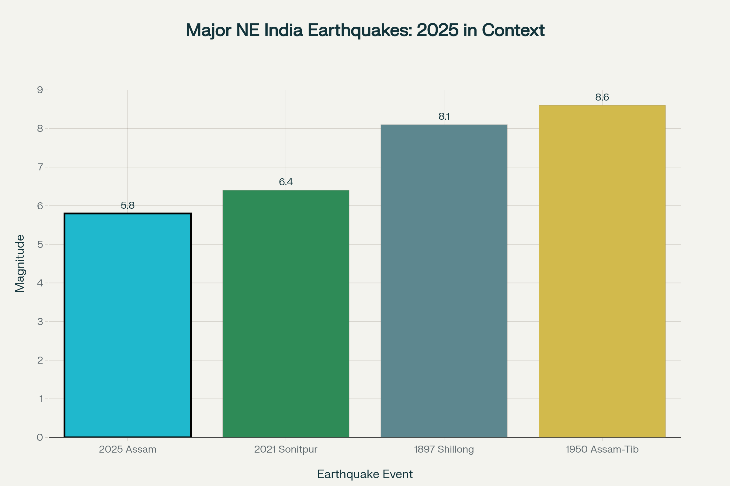
Northeast India Earthquake Data: Current 5.8 Magnitude Assam Earthquake in Historical Context and Regional Seismic Activity Trends
Aftershock Activity and Scientific Analysis
- Strike-slip fault mechanism identified through moment tensor inversion analysis of the tremor
- Connection established between current jolt and 2021 magnitude 6.4 Sonitpur earthquake through geological fault mapping
The National Center for Seismology’s preliminary analysis of the Assam earthquake jolt revealed a strike-slip fault mechanism through moment tensor inversion, indicating horizontal movement along the fault plane rather than vertical displacement. Two significant aftershocks measuring magnitudes 3.1 and 2.9 followed the main seismic event, with seismologists predicting additional aftershocks in similar magnitude ranges as stress continues to redistribute along the fractured fault system. Scientific examination shows the tremor occurred in close proximity to the April 28, 2021, magnitude 6.4 Sonitpur earthquake, suggesting ongoing tectonic stress release along the same geological structures.
The relatively rapid attenuation of seismic shaking from the Assam earthquake jolt results from pre-existing fractures and cracks in the source zone, created during the 2021 Sonitpur event and its subsequent aftershock sequence. More than 20 broadband seismic stations operated by the National Center for Seismology successfully recorded the earthquake, providing comprehensive data for analysis and demonstrating India’s enhanced seismic monitoring capabilities. The Assam earthquake jolt generated three felt reports through official channels, with intensity ratings between III and VI on the Modified Mercalli scale, confirming the event’s significant impact across the region.
Public Safety and Emergency Preparedness
- Hashtag #Guwahati trended nationally as citizens shared real-time updates during the seismic event
- No reports of structural collapse or injuries despite widespread building evacuation during the tremor
Social media platforms erupted with activity during the Assam earthquake jolt, as #Guwahati rapidly climbed trending lists while residents shared photographs, videos, and safety updates from across the affected region. Terrified residents in Guwahati described intense fear during the seismic event, with one person stating “It felt like it would never stop” and another remarking “For a minute, I thought I was dead. I genuinely believed the roof would cave in”. Despite the widespread panic caused by the tremor, emergency response teams across Assam, Arunachal Pradesh, and Manipur reported no structural damage to buildings or infrastructure, demonstrating improved construction standards in the seismically active region.
The rapid evacuation response during the Assam earthquake jolt reflects increased public awareness of earthquake safety protocols, with residents instinctively moving to open areas as buildings swayed during the seismic event. Government disaster management officials confirmed that emergency response systems activated immediately following the earthquake, with monitoring teams maintaining vigilance for potential aftershocks and assessing any delayed damage reports. The Assam earthquake jolt serves as a reminder of the critical importance of earthquake preparedness in Zone V regions, where residents must remain ready for potentially stronger seismic events given the area’s geological characteristics.
Final Perspective
The September 14, 2025, Assam earthquake jolt exemplifies the ongoing seismic challenges facing Northeast India, where complex tectonic forces continue generating significant earthquakes along major fault systems including the Kopili Fault and Himalayan thrust structures. While this magnitude 5.8 seismic event caused no casualties or major damage, it underscores the region’s vulnerability and the critical importance of continued earthquake preparedness, building code enforcement, and public education in India’s highest-risk seismic zone.
The scientific community’s comprehensive monitoring and rapid analysis of the tremor demonstrates significant advances in seismological capabilities, providing valuable data for understanding regional earthquake patterns and improving future hazard assessments. As aftershocks continue following the Assam earthquake jolt, residents across Northeast India remain vigilant while authorities maintain enhanced monitoring protocols to ensure public safety in this geologically dynamic region.