
Key Highlights:
- At least 28 confirmed deaths from devastating Darjeeling landslides across multiple locations in West Bengal hills
- Record-breaking 300mm rainfall in 12 hours triggers worst natural disaster in decade across the region
- NDRF deploys five specialized teams as rescue operations continue at over 40 affected sites
Devastating Darjeeling landslides have claimed at least 28 lives while rescue teams struggle to reach isolated villages following unprecedented rainfall that recorded 300mm in just 12 hours across West Bengal’s hill regions. The catastrophic events represent one of the worst natural disasters to hit the state’s hills in a decade, with continuous rainfall hampering rescue efforts and raising fears of additional casualties from these Darjeeling landslides. The Darjeeling landslides crisis began when relentless precipitation triggered massive soil movements across multiple locations including Mirik, Sukhiapokhri, Jorebunglow, and Nagrakata, leaving entire communities cut off from emergency services.
Darjeeling, Kurseong & Kalimpong hit by landslides; Jalpaiguri, Alipurduar submerged as Teesta overflows. Many lives lost. Administration is on the ground, doing their job efficiently.
— Tanmoy Ghosh (@Tanmoy_Fetsu) October 5, 2025
I’m deeply anguished. My thoughts and prayers are with everyone affected. If anyone needs… pic.twitter.com/UAYbc8niSN
North Bengal Development Minister Udayan Guha confirmed the rising death toll, stating that several people remain missing and the situation remains “extremely challenging” with rescue operations ongoing at Darjeeling landslides sites. The disaster has devastated popular tourist destinations during the Durga Puja holiday season, with Mirik recording the highest casualties of 11 deaths among the affected areas. Chief Minister Mamata Banerjee announced plans to visit the disaster-affected regions while ensuring government compensation for families impacted by the Darjeeling landslides crisis.
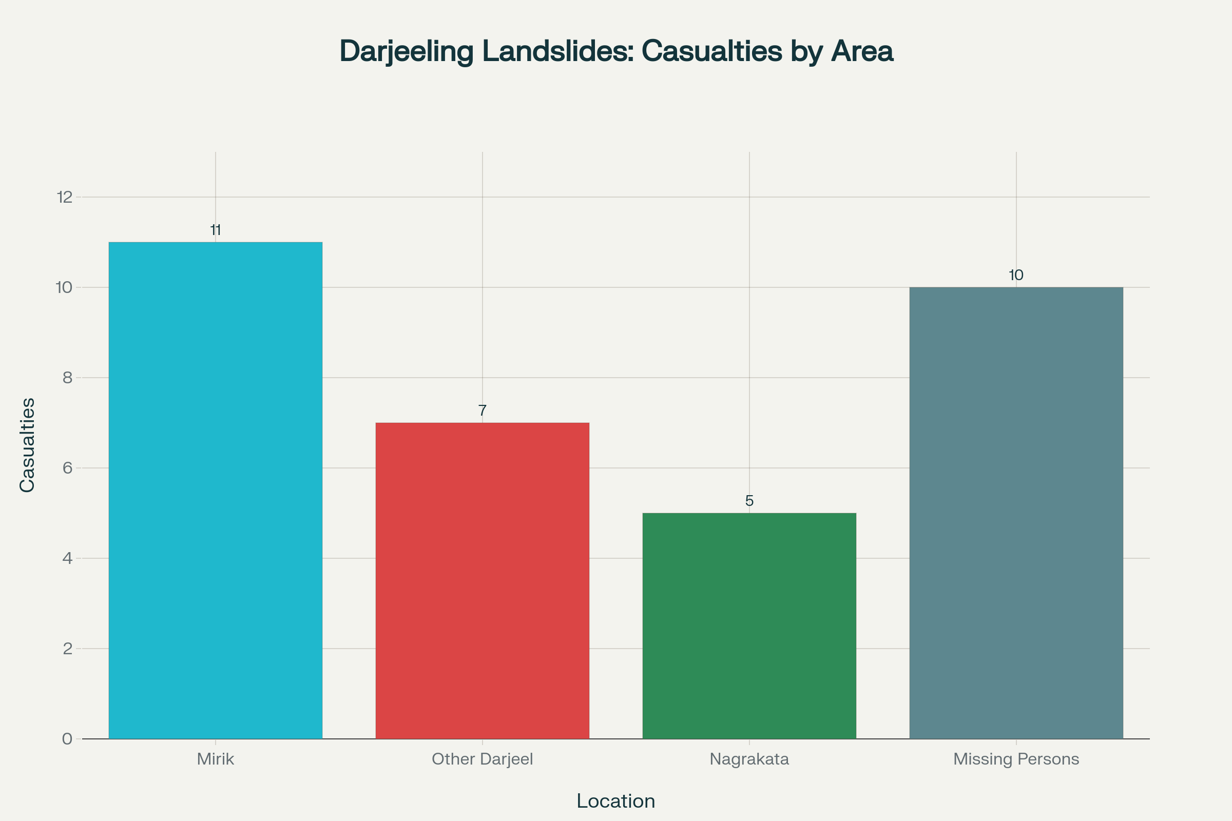
Distribution of casualties from Darjeeling landslides across affected locations in October 2025
Massive Rescue Operations Deployed Across Affected Areas
- NDRF has deployed five specialized teams across affected districts for comprehensive rescue operations
- Over 40 affected points identified across the hills requiring clearing operations with heavy earth-moving machinery
- Thousands of tourists remain stranded in isolated hill pockets with disrupted communication networks
NDRF Deputy Inspector General Mohsen Shahedi confirmed the deployment of multiple rescue teams working “around the clock” to locate missing persons and assist villagers stranded by the disaster. The rescue operations face significant challenges as continuous rainfall hampers access to remote areas where the Darjeeling landslides crisis has severed communication lines completely. Officials fear the death toll could rise substantially once teams reach upper hill regions that remain cut off from the rest of the district due to Darjeeling landslides.
Clearing operations are underway at more than 40 locations affected by the disaster, with teams focusing on reopening critical routes including the Mirik-Darjeeling and Sukhiapokhri roads. The rescue efforts involve heavy earth-moving machinery to locate individuals feared trapped beneath massive debris piles, while specialized search teams work to reach isolated villages. Forest staff have deployed elephants for rescue operations in certain areas, while car and elephant safaris in affected parks have been suspended indefinitely.
The Darjeeling landslides crisis has left thousands of tourists stranded during the Durga Puja holiday season, with authorities advising them to remain in place until safe evacuation can be organized. The state government has announced additional North Bengal State Transport Corporation buses from Siliguri to Kolkata to assist tourists while bearing the cost of rescue operations. Emergency hotlines have been established, with Bengal police setting up a dedicated number (9147889078) for stranded tourists and residents.
Record-Breaking Rainfall Triggers Catastrophic Soil Movements
- The region recorded 261mm rainfall in 24 hours, classified as “extremely heavy rainfall” by meteorological standards
- Gajoldoba in Jalpaiguri reported a staggering 300mm, the highest recorded during the crisis
- Regional weather systems extending across Sikkim, Bhutan, and Nepal have contributed to widespread devastation
The unprecedented rainfall patterns created catastrophic conditions that triggered the disaster, with Darjeeling recording 261mm of rain in just 24 hours from Saturday morning, officially classified as “extremely heavy rainfall” by meteorological standards. Neighboring areas experienced similarly intense precipitation, with Gajoldoba in Jalpaiguri recording a staggering 300mm of rainfall, while Cooch Behar received 192mm and Jalpaiguri recorded 172mm. These extreme weather conditions created ideal circumstances for Darjeeling landslides while generating flash flood conditions in the Dooars region at the foothills.
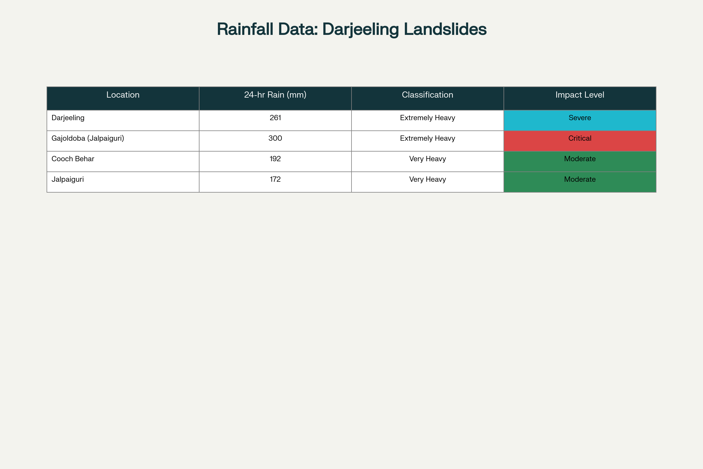
Rainfall measurements across affected districts during Darjeeling landslides October 2025
The heavy rainfall that triggered the disaster began around 6 PM on Saturday and continued to impact neighboring regions including Sikkim, Bhutan, and Nepal, where combined casualties exceed 50 people due to similar events. The regional scope of this weather system has created coordinated disaster response challenges across international borders while highlighting the vulnerability of Himalayan foothill communities. Weather forecasters continue monitoring the eastward-moving storm system that originated over eastern Uttar Pradesh and threatens to bring additional rainfall to areas already affected.
Chief Minister Mamata Banerjee explained the severity of the situation, stating “Yesterday night there was sudden rainfall exceeding 300 mm in 12 hours in North Bengal” which directly contributed to the crisis. The extreme precipitation has forced rivers throughout the region to rise rapidly, with multiple water bodies approaching or exceeding danger levels. The combination of saturated soil conditions and steep terrain created ideal circumstances for these Darjeeling landslides to occur, forcing authorities to maintain high alert status even as immediate rescue operations continue.
Bhutan Dam Crisis Compounds Emergency Response
- Bhutan’s National Centre for Hydrology and Meteorology confirms Tala Dam gate malfunction causing river water overflow
- NDRF Alipurduar team placed on “highest alert level” with all personnel recalled from leave
- Additional 15 rescuers deployed from Siliguri to strengthen response in low-lying Indo-Bhutan border areas
Bhutan’s National Centre for Hydrology and Meteorology officially alerted West Bengal authorities after the Druk Green Power Corporation reported a critical malfunction in Tala Hydropower Dam gates, which failed to open and caused river water to spill over the structure. This technical failure has created immediate downstream flooding threats for West Bengal’s Dooars region, particularly affecting districts of Jalpaiguri and Cooch Behar, compounding the existing crisis. The NCHM’s Flood Warning Group continues coordinating with the power corporation for real-time monitoring while maintaining communication with West Bengal disaster management authorities.
The National Disaster Response Force has responded by placing its Alipurduar-based team on the highest alert level while recalling all personnel from leave and deploying 15 additional rescuers from the Regional Response Centre in Siliguri. The enhanced deployment focuses on strengthening ground response capabilities in low-lying areas near the Indo-Bhutan border that face the most immediate flooding risk, adding to the challenges posed by the ongoing hills Darjeeling landslides crisis. District authorities across North Bengal have been advised to maintain maximum readiness, particularly in riverine zones vulnerable to rapid water level changes.
The flooding threat is compounded by meteorological conditions as a storm system moving eastward from Uttar Pradesh approaches the Dooars region already impacted by Darjeeling landslides. If heavy rainfall continues in Bhutan’s hills, rivers in North Bengal are expected to swell rapidly, significantly increasing flash flood risks in areas already vulnerable. The Wangchu river, known as Raidak in Bengal, was already flowing above danger levels, heightening concerns about additional downstream impacts during this crisis period.
Government Response and Recovery Planning
- West Bengal Chief Minister announces comprehensive relief package including compensation for affected families
- State government establishes 24×7 control rooms for disaster coordination and tourist assistance
- Local MP calls for declaring the crisis a “state-level disaster” requiring enhanced federal support
Chief Minister Mamata Banerjee has announced a comprehensive government response including financial compensation for families of victims and guaranteed employment for one family member, though specific amounts remain unspecified. The state government has established round-the-clock control rooms to coordinate relief efforts for those affected and assist stranded tourists in North Bengal. Banerjee emphasized that hotels must not overcharge tourists during the crisis, stating that their safety remains a government responsibility.
The West Bengal Disaster Management Department has activated its comprehensive disaster response protocols, operating under the framework established by the Disaster Management Act of 2005. The department’s mandate includes establishing necessary systems, structures, and resources for reducing disaster risks while ensuring continuity of development and minimizing disruption to economic activity. State authorities have coordinated with central agencies including the NDRF to ensure adequate resource deployment across affected areas.
Darjeeling MP Raju Bista has formally requested the Chief Minister to declare the crisis a “state-level disaster,” which would unlock additional federal funding and resources for recovery efforts. The request reflects the scale of destruction that extends beyond local government capacity to address effectively, particularly given the infrastructure damage and long-term recovery requirements. Political leaders across party lines have pledged support for affected communities, with various officials calling for immediate resource mobilization and priority distribution of relief materials.
Critical Assessment of the Regional Crisis
The disaster demonstrates the complex vulnerability of Himalayan foothill communities to extreme weather events that are becoming increasingly frequent due to climate change patterns. The combination of steep terrain, saturated soil conditions, and unprecedented rainfall created the perfect conditions for the catastrophic Darjeeling landslides that have devastated multiple communities across the region. As rescue operations continue amid challenging conditions, the focus shifts toward long-term recovery planning that addresses both immediate humanitarian needs and systemic vulnerabilities that contributed to the severity of the crisis.
The ongoing emergency underscores the importance of robust early warning systems and enhanced disaster preparedness measures, particularly given the region’s susceptibility to similar events. Recovery efforts will require sustained coordination between multiple agencies and governments to address infrastructure restoration, community rehabilitation, and enhanced disaster preparedness for future extreme weather events.