
Key Highlights:
- Active Western Disturbance to impact J&K from October 4-7 with heavy rain and snowfall in higher reaches
- Emergency protocols activated with helpline 112 and specialized disaster management teams on high alert
- Transport disruptions expected on Jammu-Srinagar and Srinagar-Leh highways with landslide risks
Western Disturbance Analysis and Historical Context
The current J and K weather advisory addresses an unusually strong Western Disturbance for early October, with the IMD forecasting widespread precipitation across Jammu & Kashmir from October 5-7, 2025. According to meteorological research spanning 1980-2019, Western Disturbances typically occur with an average frequency of 2-3 cases per month during winter seasons, with peak activity observed from January through April. The current system represents an anomaly in seasonal patterns, occurring during a period when such intense disturbances are historically less common.
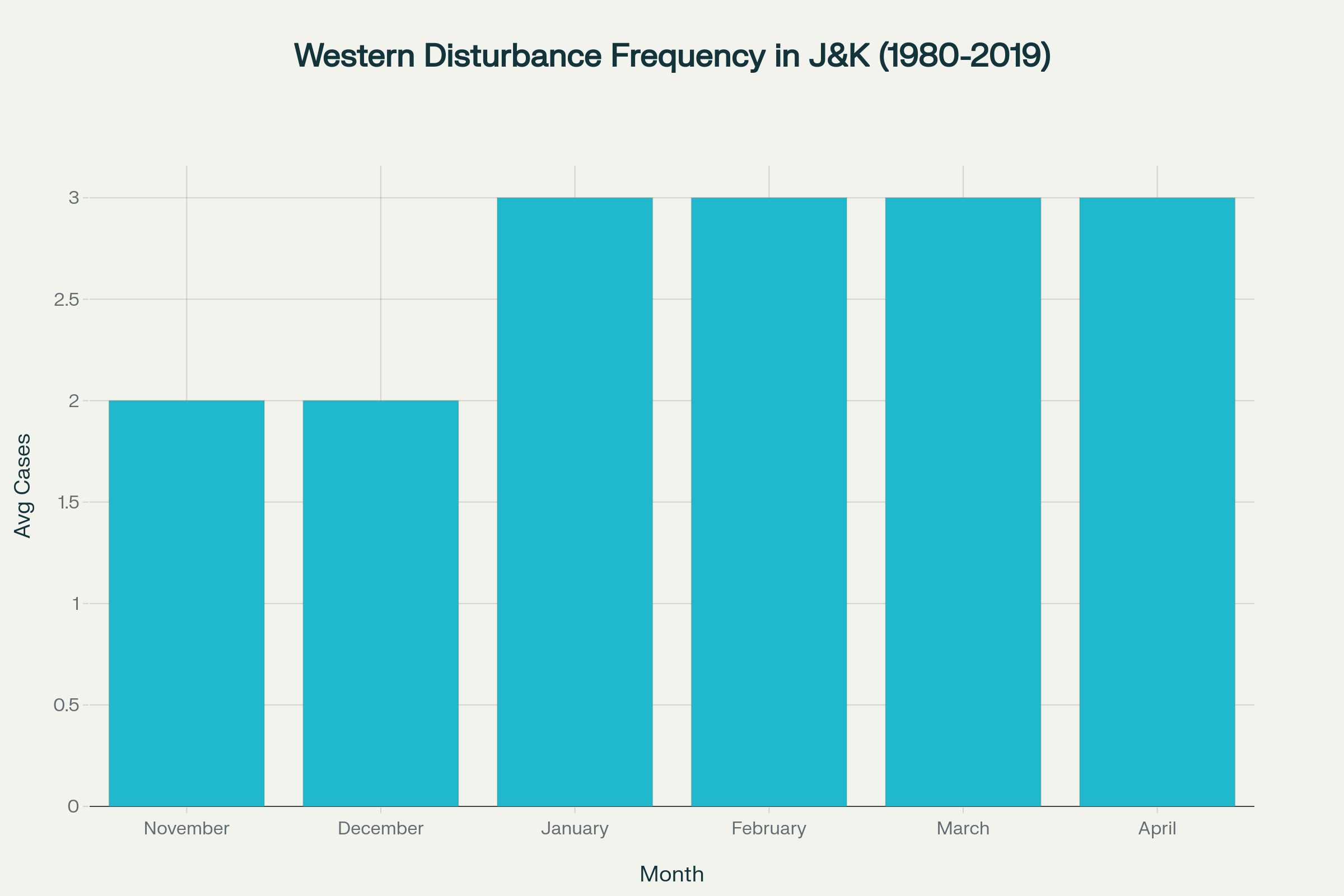
Monthly frequency of Western Disturbances affecting Jammu & Kashmir region
Historical data reveals that Western Disturbances have been increasing in frequency over the last 70 years, particularly during spring and early summer months. Climate research indicates that WD frequency has significantly increased in January and April through July, attributed to strengthening subtropical jet streams and delayed northward migration patterns. The current J and K weather advisory aligns with these evolving climate trends, demonstrating enhanced intensity and earlier seasonal occurrence.
Weather update J&K:Possibility of hvy to very hvy rain in many dists of JMU Div & moderate to hvy rain in South KMR during 5 Oct evng-7 Oct AN.
— Meteorological Centre Srinagar (@metsrinagar) October 4, 2025
Moderate/heavy snow over few higher reaches of South KMR/PIRPANJAL Range/Chenab Valley.
Landslides/shooting stones at vulnerable places. pic.twitter.com/5DQ33lA8Up
Recent rainfall statistics preceding this J and K weather advisory show significant precipitation deficits across both divisions. During the week of September 26 to October 2, 2025, Kashmir Division received only 0.04mm of rainfall against a normal expectation of 6.02mm, representing a 99.34% deficit. Similarly, Jammu Division recorded 3.93mm compared to normal levels of 10.37mm, indicating a 62.10% deficit. These conditions create heightened vulnerability for the incoming weather system covered in the current J and K weather advisory.
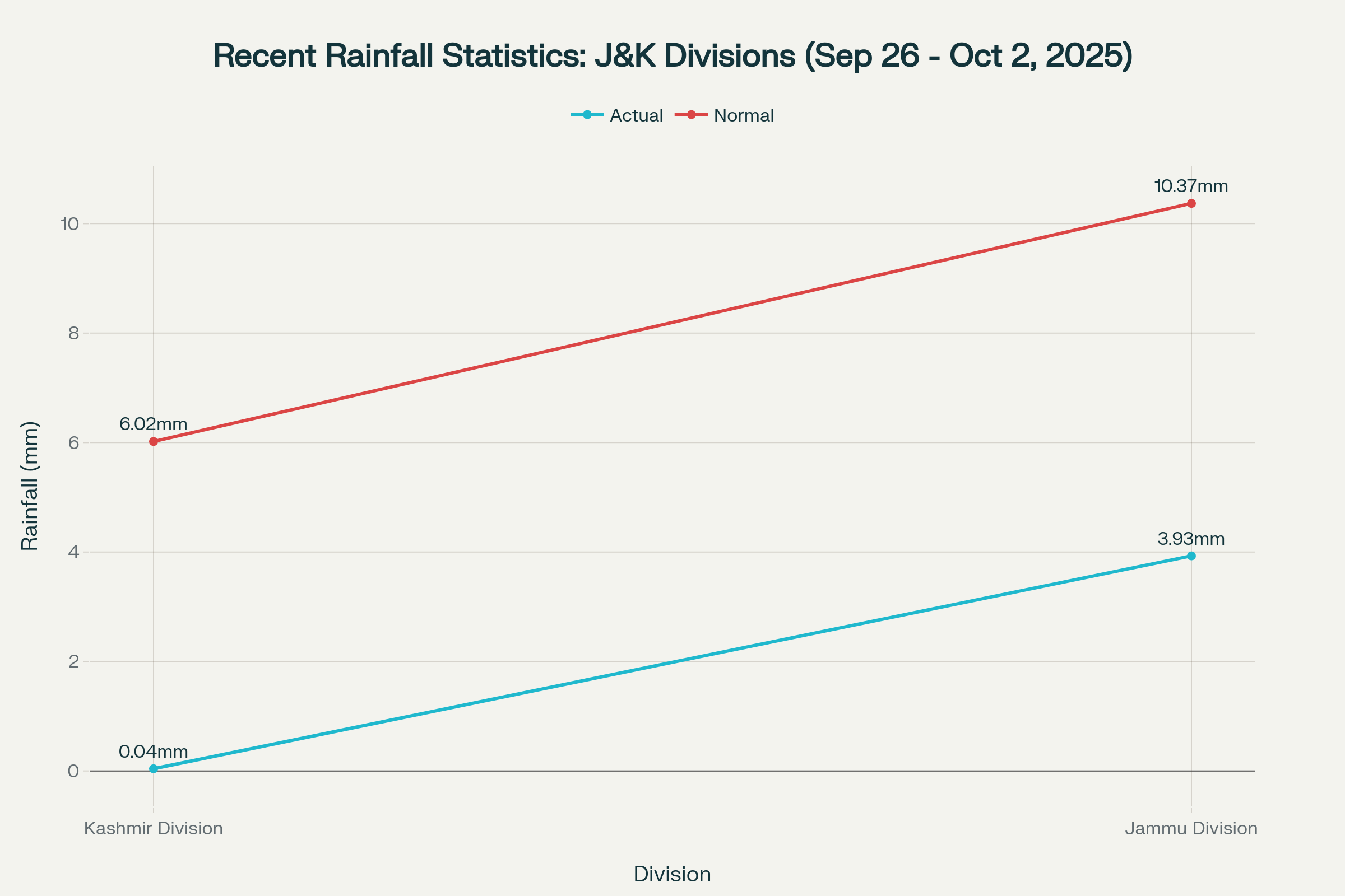
Comparison of actual versus normal rainfall in J&K divisions during late September 2025
Emergency Response Framework and Institutional Preparedness
The J and K weather advisory has triggered comprehensive emergency response protocols across all administrative levels. The J&K Emergency Relief Organization, operating under the Department of Disaster Management, Relief, Rehabilitation & Reconstruction, has activated all frontline departments, disaster management teams, and emergency responders. This coordinated response structure reflects lessons learned from previous major weather events, including the devastating 2014 floods that affected 1.5 million households across 5,794 villages.
| Emergency Contact Information | Contact Details |
|---|---|
| Primary Emergency Helpline | 112 |
| UT Emergency Operation Centre (Landline 1) | 0194-2502254 |
| UT Emergency Operation Centre (Landline 2) | 0194-2950767 |
| Emergency Mobile Contact 1 | 7006067453 |
| Emergency Mobile Contact 2 | 9086131746 |
The institutional framework supporting this J and K weather advisory includes 22 District Disaster Management Authorities headed by Deputy Commissioners, two divisional authorities for Kashmir and Jammu regions, and specialized State Disaster Response Force (SDRF) battalions. Emergency Operations Centers have been established at all district headquarters, equipped with 16 specialized task forces covering planning, coordination, warning systems, law enforcement, and search and rescue operations.
This J and K weather advisory emphasizes community-level preparedness, recognizing that local communities serve as first responders in disaster situations. Citizens have been instructed to maintain emergency supplies including water, food, medicines, blankets, batteries, and torches. The advisory specifically warns against entering flooded waterways, approaching fallen electrical equipment, and traveling on landslide-prone routes during the weather event.
Regional Impact Assessment and Transportation Infrastructure
The J and K weather advisory identifies specific geographical areas facing maximum risk during the October 5-7 weather event. Higher altitude regions including Anantnag-Pahalgam, Kulgam, Sinthan Pass, Shopian, Pir Ki Gali, Sonamarg-Zojila, Bandipora-Razdan Pass, Gulmarg, and Kupwara-Sadhna Pass are expected to receive heavy snowfall. Middle altitude zones may witness light snowfall, while Kashmir plains will experience moderate to heavy rainfall.
| Region | Expected Weather Impact | Risk Level |
|---|---|---|
| Higher Reaches (Above 3000m) | Heavy Snowfall | Very High |
| Middle Altitudes (1500-3000m) | Light Snowfall | High |
| Kashmir Plains | Moderate to Heavy Rain | High |
| Jammu Division | Heavy Rain + Thunderstorms | Very High |
The J and K weather advisory warns of significant transportation disruptions affecting critical infrastructure corridors. The Jammu-Srinagar National Highway, serving as the primary connectivity link between Kashmir valley and mainland India, faces potential closure due to landslides and heavy precipitation. Similarly, the Srinagar-Leh highway connecting Ladakh region may experience blockages, particularly at high-altitude passes.
Agricultural operations across Jammu & Kashmir have been suspended from October 5-7 as specified in the J and K weather advisory, protecting farmers and equipment during severe weather conditions. This precautionary measure coincides with post-harvest activities and Rabi season preparation, making agricultural sector compliance essential for minimizing economic losses. The advisory emphasizes securing livestock and avoiding unnecessary animal movement during the weather event.
Meteorological Data Analysis and Climate Implications
The J and K weather advisory occurs within broader seasonal transition patterns, following the southwest monsoon withdrawal from the Western Himalayan Region on September 26, 2025. Seasonal precipitation analysis indicates that Northwest India received 127% of Long Period Average (LPA) during the 2025 monsoon season, creating enhanced moisture conditions for the current weather system. This above-normal moisture availability contributes significantly to the intensity warranting the comprehensive J&K weather advisory.
Long-term precipitation patterns in Kashmir valley show annual averages of 1,005.5mm with high inter-station variability. Research indicates that Kashmir region receives approximately 71.54% of annual precipitation from October to May, with the remaining 28.46% occurring during monsoon months. The current J and K weather advisory addresses conditions during this critical precipitation period when the region depends heavily on Western Disturbances for water resources.
Climate trend analysis reveals significant implications for future J and K weather advisory patterns. Western Disturbance frequencies have shown decreasing trends during November and March but increasing trends during February, with varying impacts across different meteorological stations. Stations like Gulmarg and Baderwah demonstrate decreasing precipitation trends, while locations such as Banihal and Batote show increasing February rainfall patterns.
The current J and K weather advisory reflects broader climate adaptation challenges as Western Disturbances become more frequent and intense. Research indicates that WD season lengthening, with disturbances becoming more common in May, June, and July months where they were previously rare. This trend necessitates enhanced preparedness frameworks and more sophisticated early warning systems for future J and K weather advisory scenarios.
Final Assessment and Long-term Preparedness
The comprehensive J and K weather advisory for October 5-7, 2025 demonstrates the critical importance of integrated disaster management systems in addressing evolving weather patterns. The coordinated response involving multiple agencies, early warning systems, and public safety protocols represents best practices in emergency preparedness. This J&K weather advisory underscores the necessity for continued investment in meteorological infrastructure, community awareness programs, and climate adaptation strategies.
The successful implementation of safety measures outlined in this J and K weather advisory depends on sustained public cooperation, institutional coordination, and technological advancement in forecasting capabilities. Future J and K weather advisory effectiveness will require enhanced understanding of changing Western Disturbance patterns, improved early warning dissemination, and strengthened community resilience frameworks. The current weather event serves as a critical test of preparedness systems and provides valuable insights for managing similar future scenarios requiring comprehensive J and K weather advisory responses.