
Key Highlights:
- Heavy rain batters Mumbai with 134.4 mm rainfall at Colaba observatory in 24 hours, triggering severe waterlogging and traffic disruptions across the city
- IMD escalates warnings from yellow to orange alerts, with red nowcast alerts issued for intense thunderstorms and gusty winds
- Critical infrastructure impacts include Andheri Subway closure, monorail service suspension, and delays across Central and Harbour railway lines
Opening Overview
Heavy rain batters Mumbai for the second consecutive day on September 15, 2025, as intense overnight showers devastated the financial capital, causing widespread waterlogging and significant disruptions to daily life. The India Meteorological Department (IMD) has escalated its weather warnings, upgrading from yellow to orange alerts for Mumbai, Thane, Palghar, and Raigad districts, while issuing critical red nowcast warnings for three-hour periods of intense rainfall as the monsoon fury continues. The downpour has particularly impacted South-Central Mumbai, with weather stations recording substantial precipitation levels that have overwhelmed the city’s drainage systems as heavy rain batters Mumbai relentlessly.
अंधेरी सबवे (अंधेरी पश्चिम) येथे एक ते दीड फूट पावसाचे पाणी साचल्याने तेथील वाहतूक बंद करण्यात आली असून तेथील वाहतूक गोखले ब्रीज मार्गे वळविण्यात आली आहे.#MTPTrafficUpdates
— Mumbai Traffic Police (@MTPHereToHelp) September 15, 2025
According to official IMD data, the Colaba coastal observatory registered 134.4 mm of rainfall in the 24-hour period ending 8:30 AM on Monday, while Santacruz received 73.2 mm during the same timeframe when intense precipitation struck the metropolis. This sustained weather pattern has created challenging conditions for the city’s 12 million residents, with authorities implementing emergency traffic diversions and public transport disruptions to ensure safety during the ongoing monsoon activity as heavy rain batters Mumbai continuously.
Current Weather Conditions and Meteorological Analysis
The intense downpour that commenced late Sunday night intensified during the early morning hours of September 15, with peak intensity recorded between 2:00 AM and 5:30 AM when heavy rain batters Mumbai most severely. Weather monitoring stations across Mumbai documented varying precipitation levels, with Bandra recording 82 mm, Byculla receiving 73 mm, and Tata Power station measuring 70.5 mm during this period of extreme weather activity. The IMD’s Regional Meteorological Centre has forecast continued moderate to intense showers until 10 AM, followed by very heavy precipitation accompanied by thunderstorms, lightning, and gusty winds at isolated locations throughout the city as heavy rain batters Mumbai.
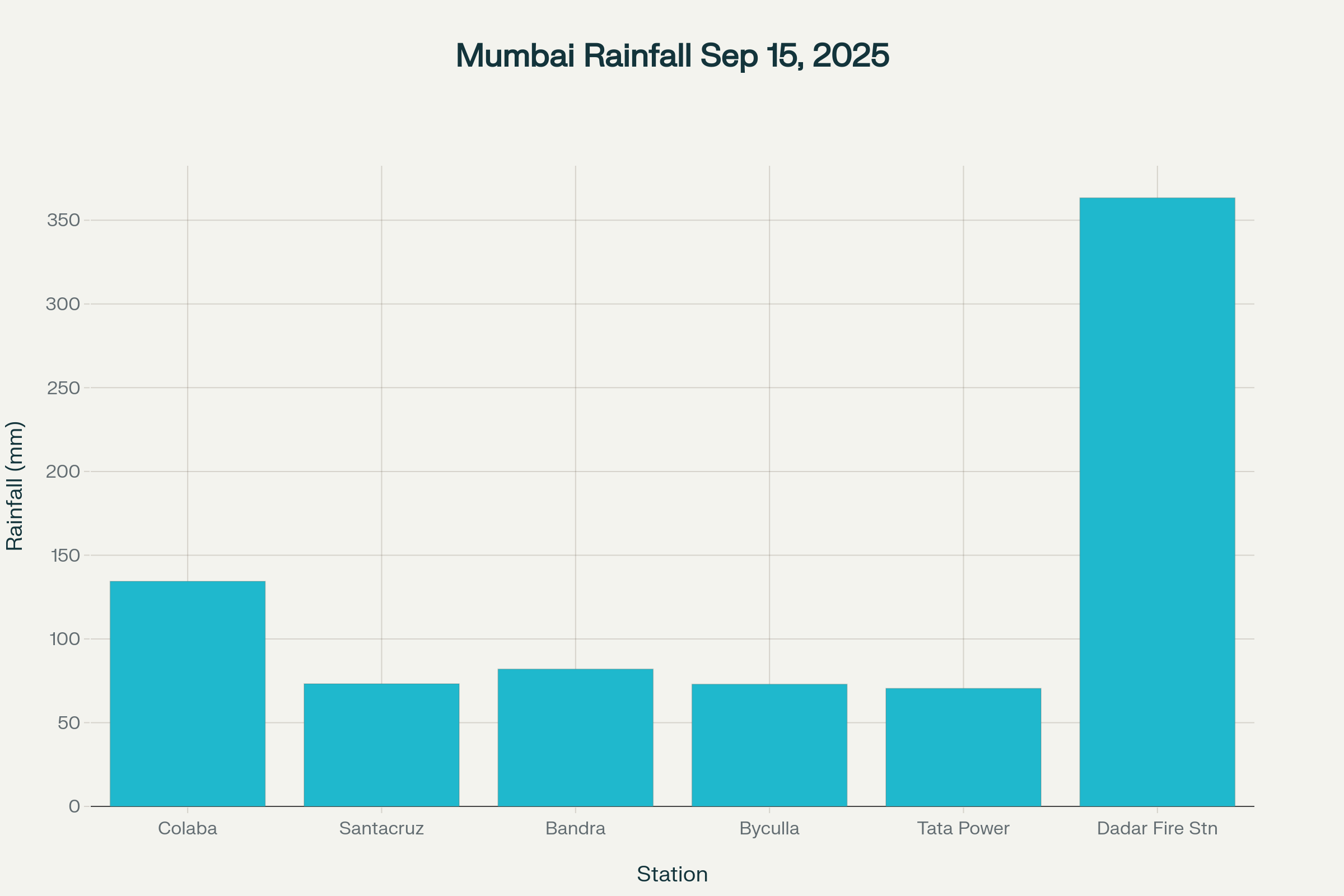
Mumbai rainfall measurements across key weather monitoring stations during the heavy rain event on September 15, 2025
- Mumbai’s automatic weather stations indicate the city division received an average of 111.19 mm of rainfall, making it the most affected area during this weather episode
- Temperature conditions remain favorable for continued precipitation, with maximum temperatures around 30°C and minimum temperatures near 24°C during the ongoing monsoon activity
The current weather pattern is driven by a low-pressure system over north Telangana and Vidarbha, coupled with a cyclonic circulation that meteorologists expect to move northwest and persist as an upper-level disturbance while heavy rain batters Mumbai. This system is generating the sustained precipitation conditions across the broader Maharashtra region, with the IMD predicting continued rainfall activity over the coming days as the monsoon intensifies.
Real-time monitoring data from the Mumbai Rainfall portal shows maximum 24-hour precipitation of 363.4 mm recorded at Dadar Fire Station, demonstrating the extreme variability in distribution across the metropolitan area when heavy rain batters Mumbai. The dense network of 139 rain gauges spread across Mumbai city and suburban areas provides crucial data for disaster management agencies coordinating response efforts during this period of intense weather activity.
IMD Alert System and Weather Warning Framework
The India Meteorological Department has implemented a comprehensive color-coded warning system to communicate the severity of weather events and associated hazards to citizens and authorities when heavy rain batters Mumbai. For the current situation, the IMD initially issued yellow alerts, indicating severely bad weather spanning several days, before escalating to orange alerts as the monsoon fury intensified and rainfall reached dangerous levels. The orange alert system warns of extremely bad weather conditions with potential for significant disruption to commuter traffic, road and rail closures, and interruption of power supply while heavy rain batters Mumbai.
- Red nowcast warnings were issued at 8:30 AM for three-hour periods, indicating immediate threats from intense precipitation, thunderstorms, and gusty winds during the ongoing weather crisisindianexpress+1
- The warning framework covers Mumbai, Thane, Palghar, Raigad, Ratnagiri, and ghat regions of Pune under orange alert status as heavy rain batters Mumbai and surrounding areas
The IMD’s decision-support system utilizes an array of monitoring instruments including Automated Weather Stations, Automated Rain Gauges, Doppler Weather Radars, and satellite observations to track precipitation patterns and issue timely warnings when heavy rain batters Mumbai. This comprehensive monitoring network enables meteorologists to provide forecasts up to five days in advance and assess uncertainty levels in predictions related to weather events during monsoon periods.
Maharashtra’s seasonal rainfall monitoring shows the state has received 83.9% of normal precipitation till September 14, 2025, indicating that the current episode contributes to above-average monsoon performance for the region while heavy rain batters Mumbai. The state government’s Maharain portal tracks district-wise rainfall data, showing significant accumulations across multiple districts during recent precipitation activity across the region.
Traffic Disruptions and Infrastructure Impact
The overnight downpour has created severe disruptions to Mumbai’s transportation network, with authorities implementing emergency traffic management protocols to ensure public safety as heavy rain batters Mumbai. The most significant impact occurred at Andheri Subway in Andheri West, where accumulation of one to one-and-a-half feet of rainwater forced complete closure of vehicular traffic while intense rainfall continues. Mumbai Traffic Police immediately diverted all traffic via Gokhale Bridge, posting advisories on social media platforms to inform commuters about the route changes as heavy rain batters Mumbai.
- Central and Harbour railway lines experienced delays of 10-15 minutes due to precipitation affecting track conditions and signal operations while the monsoon fury persists
- Multiple early morning Harbour line services were cancelled, significantly inconveniencing office commuters during peak travel hours as heavy rain batters Mumbai
The Mumbai monorail system came to a complete standstill, with services halted due to unsafe operating conditions, particularly affecting the Wadala area operations while intense weather activity continues. Western Railway lines managed to maintain relatively better service levels compared to other networks, recording only minor delays of up to five minutes despite the ongoing conditions as heavy rain batters Mumbai.
Waterlogging reports emerged from multiple critical areas including King’s Circle, where visual documentation shows vehicles struggling to navigate through accumulated rainwater during the ongoing precipitation. The Eastern Express Highway experienced sluggish traffic movement due to waterlogging at Sion and King’s Circle intersections, areas historically prone to flooding during monsoon episodes when heavy rain batters Mumbai.
Emergency response teams have been deployed to monitor flood-prone locations and provide assistance to stranded commuters affected by the precipitation crisis. The Brihanmumbai Municipal Corporation (BMC) has activated its disaster management protocols, with drainage pumping systems operating at maximum capacity to manage the excess water accumulation from sustained downpours while heavy rain batters Mumbai.
Extended Weather Forecast and Regional Impact
The IMD’s extended forecast indicates that intense precipitation conditions will persist across Maharashtra, with particular intensity expected in northeast Maharashtra over the coming days as heavy rain batters Mumbai and surrounding regions. Regional precipitation data shows significant rainfall accumulation, with Konkan, Goa, and Marathwada recording 120-200 mm, while Madhya Maharashtra and East Madhya Pradesh received 70-110 mm during the recent weather period of monsoon activity.
- Pune experienced severe nighttime thunderstorms and intense precipitation on Sunday, prompting red alert issuance from 4 AM to 7 AM on Monday as conditions similar to the current weather crisis affected the region
- Red alerts were also activated for Solapur and Ahmednagar, with orange alerts for Thane and Raigad districts as heavy rain batters Mumbai extends regionally
The broader weather pattern indicates that precipitation activity will continue to affect multiple districts, with yellow alerts issued for Nashik, Palghar, Jalana, and Nagpur regions as the same system influences the wider area during this monsoon phase. Meteorological analysis suggests that the low-pressure system driving these conditions will maintain its influence through September 16, necessitating continued vigilance and preparedness measures as heavy rain batters Mumbai.
Pune’s water reservoir system has responded positively to the recent precipitation, with three of four dams supplying the city recording fresh inflows during the period when intense rainfall affected surrounding areas. Varasgaon received 21 mm, Panshet recorded 20 mm, and Temghar measured 3 mm of precipitation, bringing combined storage to 29.09 TMC, representing nearly 100% of capacity.
The monsoon withdrawal timeline, originally projected to begin around September 15, may be delayed due to the current precipitation activity and persistent weather systems affecting the region while heavy rain batters Mumbai. IMD meteorologists are monitoring conditions closely to determine when the southwest monsoon will begin its retreat from Maharashtra after the period of intense weather activity concludes.
Closing Assessment
The current weather episode affecting Mumbai represents a significant meteorological event that has tested the city’s infrastructure resilience and emergency response capabilities as heavy rain batters Mumbai with unprecedented intensity. With official rainfall measurements exceeding 134 mm in 24 hours and continued forecasts predicting sustained precipitation through September 16, authorities and citizens must remain vigilant during this critical period of monsoon activity. The escalation from yellow to orange and red alert levels demonstrates the dynamic nature of this weather system and the importance of real-time monitoring in protecting public safety while heavy rain batters Mumbai.
Mumbai’s experience with this weather event highlights both the challenges and the preparedness measures that define monsoon management in India’s financial capital during periods of extreme rainfall. The coordination between meteorological services, transportation authorities, and emergency response teams showcases the systematic approach required to handle such intense weather conditions during critical monsoon periods. As the city continues to navigate through this challenging period, the lessons learned will contribute to improved preparedness for future monsoon challenges, ensuring that Mumbai’s 12 million residents can better cope with the realities of monsoon variability in a changing climate even when heavy rain batters Mumbai with such intensity.