
Key Highlights:
- Deep depression Bay of Bengal crossed Odisha coast near Gopalpur with sustained winds of 55-65 kmph gusting to 75 kmph as of October 2, 2025
- Heavy to very heavy rainfall warnings issued for West Bengal districts until October 6, with isolated extremely heavy falls predicted due to the weather system
- Storm moving northwest at 17-18 kmph speed, gradually weakening but continuing to bring significant precipitation across eastern India
Formation and Current Status of Deep Depression Bay of Bengal
The deep depression Bay of Bengal represents a critical weather development affecting the eastern coastal regions of India. According to the India Meteorological Department’s Special Bulletin No. 18, this deep depression Bay of Bengal crossed the Odisha coast close to Gopalpur around 1700 hours IST on October 2, 2025, with maximum sustained wind speeds of 55-65 kmph gusting to 75 kmph.
The Deep #Depression over northeast #Arabian #Sea moved northwestwards with a speed of 12 kmph during last 6 hours and lay centered at 0830 hrs IST of today, the 3rd October, 2025 over the same region near latitude 21.5N and longitude 67.0E, about 240 km wests-outhwest of Dwarka pic.twitter.com/AnUrxGEm2I
— India Meteorological Department (@Indiametdept) October 3, 2025
The deep depression Bay of Bengal originated from a cyclonic circulation that developed over the warm waters of the bay and gradually intensified into its current form. As of 1730 hours IST on October 2, the weather system was centered over south coastal Odisha near latitude 19.40°N and longitude 84.80°E, close to Gopalpur. This positioning demonstrates the typical characteristics of post-monsoon weather systems that frequently develop in the region during October.
Current meteorological analysis indicates the deep depression Bay of Bengal is moving north-northwestwards at a speed of 17 kmph during the past six hours. The system is expected to continue its northwestward trajectory across South Odisha and gradually weaken into a regular depression by October 3 morning, though the weather disturbance will continue to influence regional patterns. This movement pattern aligns with historical cyclonic disturbances that affect the Bay of Bengal region during the post-monsoon season.
The deep depression Bay of Bengal exemplifies the region’s vulnerability to intense weather systems during the October-November period, which meteorologists consider the peak season for cyclonic activity in this basin.
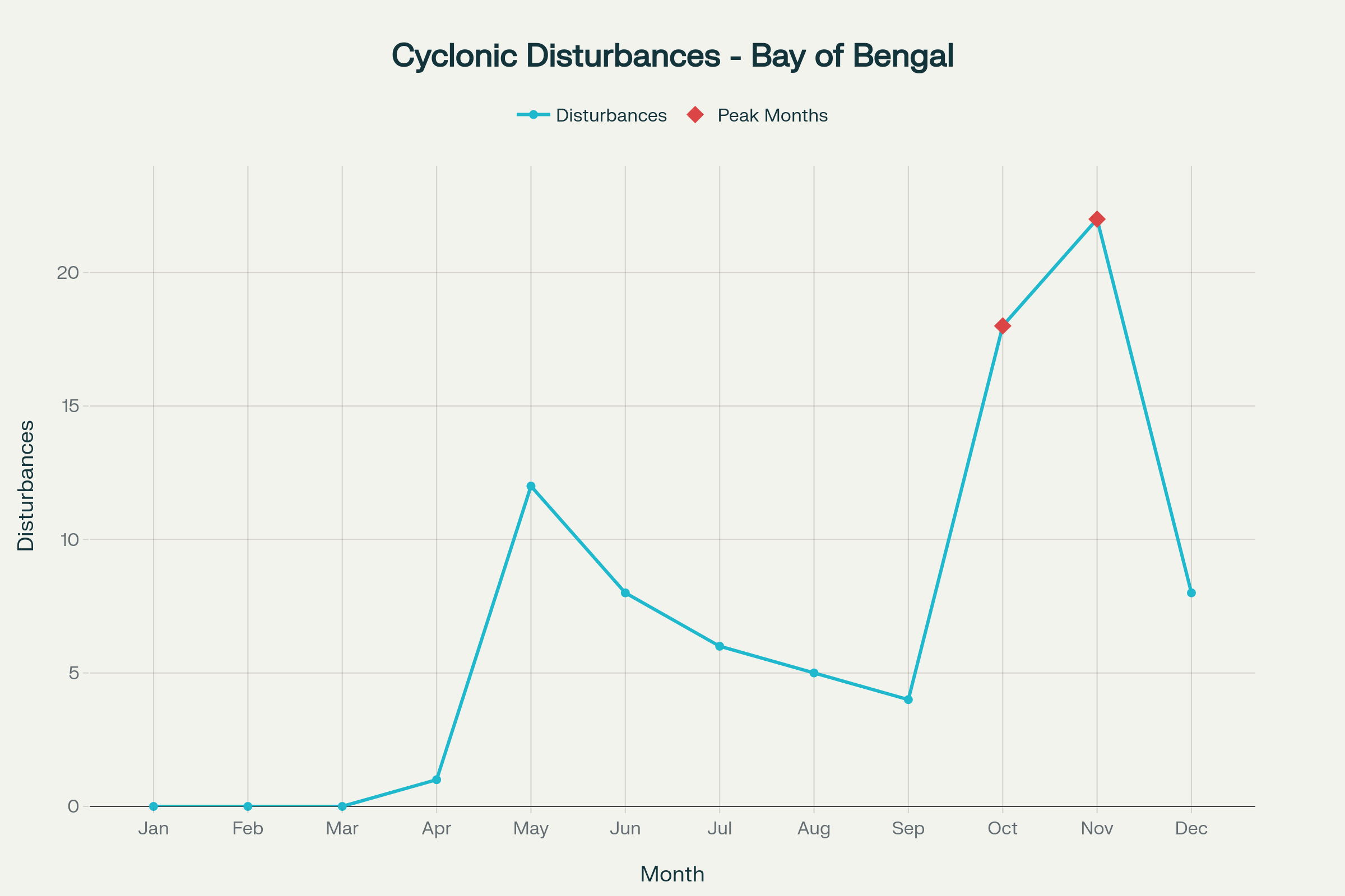
Monthly distribution of cyclonic disturbances over Bay of Bengal showing peak activity during post-monsoon season
Extensive Rainfall Predictions and Regional Impact Analysis
The deep depression Bay of Bengal has triggered comprehensive rainfall warnings across multiple districts in West Bengal and neighboring states. Heavy to very heavy rainfall measuring 07-20 cm is very likely to occur at isolated places over South 24 Parganas, Purba and Paschim Medinipur, and Jhargram districts of south Bengal, while heavy downpour of 07-11 cm is predicted for Kolkata and Howrah until Friday morning.
The rainfall intensity predictions extend beyond the immediate coastal areas, with the system expected to bring heavy precipitation at isolated places over North 24 Parganas, Bankura, Hooghly, Purba and Paschim Bardhaman, and Purulia districts of South Bengal until October 3 morning. On October 3, heavy to very heavy downpour is forecast for Birbhum district, while heavy rain warnings continue for multiple districts including Purba and Paschim Medinipur, Purulia, South 24 Parganas, Murshidabad, Paschim Bardhaman, and Bankura.
The sub-Himalayan districts of Darjeeling, Kalimpong, Alipurduar, Jalpaiguri, and Cooch Behar are expected to experience heavy to very heavy rainfall from Friday through Sunday, indicating the widespread impact of this weather disturbance across West Bengal. These predictions demonstrate the storm’s significant influence on regional weather patterns, with potential implications for transportation, agriculture, and daily activities across eastern India.
According to official rainfall data from the India Meteorological Department, the deep depression Bay of Bengal has already produced substantial precipitation, with Digha recording the state’s highest rainfall at 102 mm in 24 hours until 8:30 am on Thursday, followed by Sagar Island at 90 mm, Kontai at 70 mm, and Basirhat at 70 mm. These measurements underscore the considerable impact on local precipitation patterns.
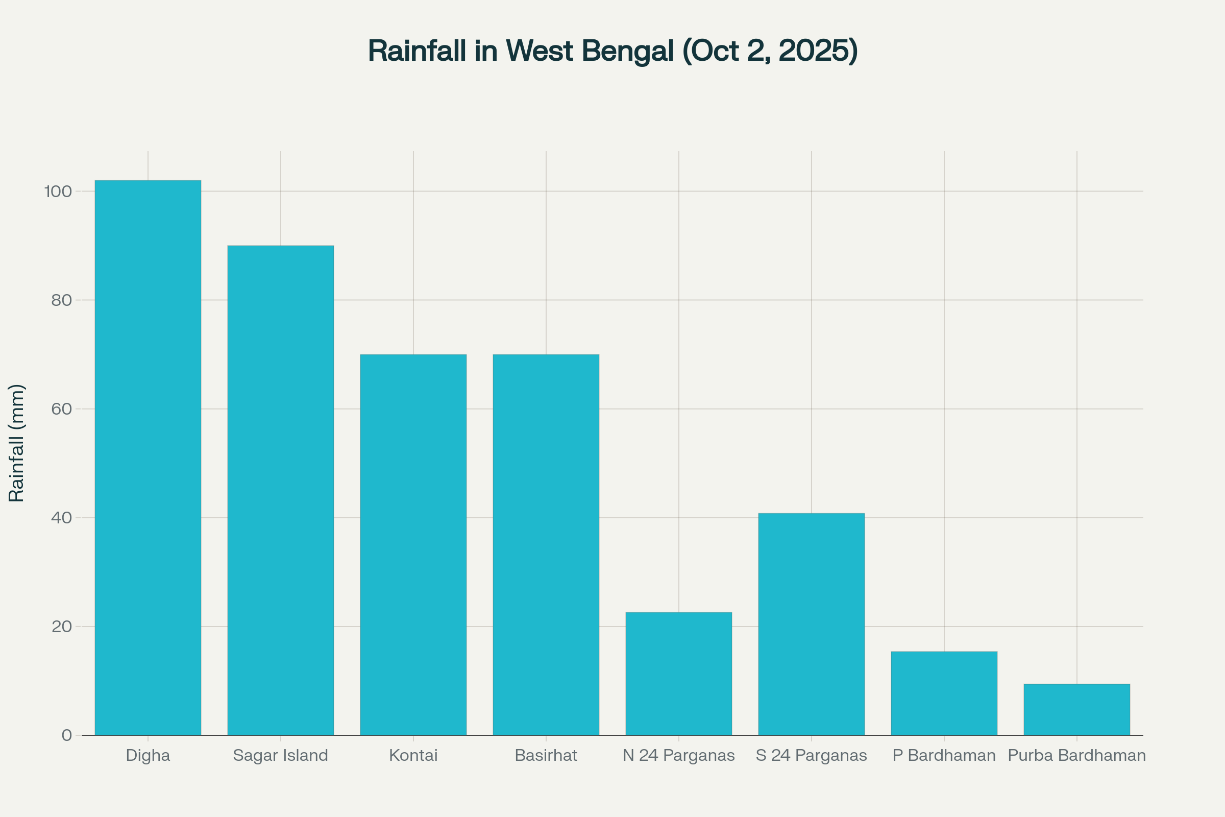
Rainfall distribution across West Bengal districts during deep depression Bay of Bengal impact on October 2, 2025
Wind Warnings and Maritime Safety Protocols
The deep depression Bay of Bengal has generated significant wind warnings across the bay and adjacent coastal areas. Squally wind speeds reaching 55-65 kmph gusting to 75 kmph are likely to prevail over westcentral and adjoining northwest Bay of Bengal and along the Odisha coast until midnight of October 2, directly associated with the circulation pattern. Wind speeds are expected to gradually decrease thereafter, becoming 40-50 kmph gusting to 60 kmph until the morning of October 3, with further reduction as the system weakens.
Along the West Bengal coast, squally wind speeds reaching 40-50 kmph gusting to 60 kmph are very likely until October 3 morning, subsequently decreasing as the weather disturbance moves inland. The sea condition is predicted to remain rough to very rough during this period, posing significant risks to maritime activities and coastal operations.
Maritime safety has become a primary concern due to the deep depression Bay of Bengal, with fishermen advised not to venture into the sea over North and Central Bay of Bengal along the West Bengal and Odisha coasts until October 3, 2025. Port authorities have issued Local Cautionary Signal No. 3 at Haldia and Kolkata Port along with sectional Signal No. 1 at Sagar Islands Port, indicating the serious nature of conditions.
The comprehensive wind warning system demonstrates the sophisticated approach taken by meteorological authorities to ensure public safety during severe weather events. These warnings are particularly crucial during the post-monsoon season when the Bay of Bengal frequently experiences cyclonic disturbances that can rapidly intensify and affect coastal populations.
Impact on Festivities and Comprehensive Public Safety Measures
The timing of this deep depression Bay of Bengal has coincided with Durga Puja celebrations, particularly affecting Bijoya Dashami festivities across West Bengal. An overcast sky and moderate rain with intense downpour spells from Thursday have dampened the spirits of Durga Puja revelers who were eager to participate in the culminating day celebrations in Kolkata and other south Bengal districts.
The weather conditions have generated specific challenges for festival organizers and participants, with potential impacts on outdoor celebrations, pandal structures, and public gatherings. The India Meteorological Department has included specific warnings about possible damages to Puja Pandals due to intense spells of rain and strong surface winds, recommending precautionary measures for protection of festival infrastructure.
Public safety concerns extend beyond festival activities, with warnings about water logging and inundation of low-lying areas, underpass roads, and reduction in visibility during intense rainfall spells. Traffic disruption affecting both rail and road transport is expected, along with potential damages to kutcha roads and vulnerable housing structures.
The authorities have issued comprehensive action suggestions including avoiding shelter under trees or electric poles, regulating traffic movement judiciously, taking shelter in safe places during intense rainfall, and avoiding movement in water-logging prone areas. Tourism and recreational activities, especially along coastal areas, are recommended to be regulated during this weather event.
Meteorological Context and Historical Significance
The current deep depression Bay of Bengal represents part of a broader pattern of cyclonic activity during the post-monsoon season. Historical data indicates that October is a particularly active month for such weather disturbances, with approximately 80% of all tropical cyclones in the north Indian Ocean forming in the Bay of Bengal region. This system follows typical seasonal patterns, as about 5-6 tropical cyclones form in the Bay of Bengal every year, of which about 2 may reach severe stages.
Statistical analysis reveals that in the last 100 years, a total of 260 cyclonic disturbances have confronted the Odisha coast, comprising 180 depressions (69%), 57 storms (22%), and 23 severe storms (9%). The data shows that more depressions typically affect the Odisha coast during July and August, while severe storms and deep depression Bay of Bengal events predominantly occur in September and October, aligning with the current weather pattern.
The Bay of Bengal’s unique geographical and meteorological characteristics make it one of the most cyclone-prone regions globally, with conditions particularly favorable for weather system formation. The warm sea surface temperatures, low wind shear, and favorable atmospheric conditions during the post-monsoon season create ideal environments for cyclonic development. Year 2024 witnessed the formation of 12 cyclonic disturbances against normal of 11.2 per year based on data during the period 1965-2023, indicating that such events are within normal ranges.
The frequency and intensity of these systems have implications for disaster preparedness, agricultural planning, and infrastructure development in coastal states. Understanding these patterns helps authorities implement appropriate warning systems and mitigation strategies to minimize the impact on vulnerable populations and economic activities.
Final Assessment and Ongoing Monitoring Requirements
The deep depression Bay of Bengal represents a significant meteorological event affecting millions of people across eastern India, particularly in West Bengal and Odisha. With sustained winds reaching 55-65 kmph and extensive rainfall predictions extending until October 6, this weather system demands continued monitoring and adherence to safety guidelines issued by meteorological authorities.
The comprehensive warning system implemented by the India Meteorological Department, including detailed rainfall predictions, wind warnings, and maritime safety measures, demonstrates the sophisticated approach to weather forecasting and disaster preparedness in the region. As the system gradually weakens while moving northwestward, residents and authorities must remain vigilant regarding potential impacts on transportation, agriculture, festival activities, and daily life across the affected regions.
The timing during Durga Puja celebrations adds cultural and social dimensions to the meteorological challenge, requiring balanced approaches to public safety and cultural traditions. Continued monitoring of the deep depression Bay of Bengal evolution and adherence to official warnings will be crucial for minimizing adverse impacts while allowing communities to safely navigate this significant weather event. The system serves as a reminder of the region’s vulnerability to intense weather patterns during the post-monsoon season and the importance of preparedness measures.