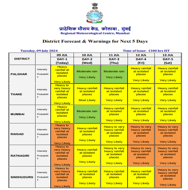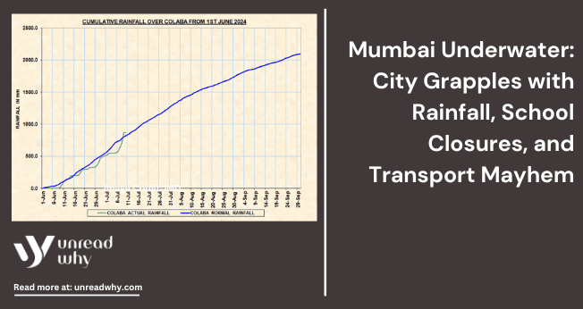
In recent months, Mumbai has faced heavy rainfall, so Bombay Municipal Corporations (BMC) have warned Mumbai’s citizens of the high tide in the next few days. IMD has issued a red alert for the possibility of high showers in the city. On Sunday, 7th July 2024, the citizens of Mumbai experienced heavy rainfall, which caused water-logging in most of the local communities. The adverse effects of the heavy rain continued with long traffic jams and disrupted local train services, and flights were cancelled for a few days.
The local weather department of Mumbai has predicted heavy overnight rainfall for more than four days from 8th July 2024. If extreme rain continues in Mumbai, this will lead to multiple hazards, such as flooding, which can increase the risk to human life. Flooding can also damage buildings and act as a massive barrier to transportation. Heavy rainfall reduces visibility for everyone, resulting in delayed transportation and being stuck in a jam for longer. These negative occurrences of heavy rain in Mumbai have caused flooding at several railway stations. High rainfall in Mumbai occurs due to the southwest monsoon and orographic influence from the nearest western Ghats.

The Indian meteorological department issues the warning labels, which are denoted in three different colours: green is for no warnings, yellow is to be updated, saffron is to be prepared, and red is for high alert. During this monsoon season, the minimum temperature in Mumbai is estimated to be about 25 to 28 degrees Celsius. The mercury level is expected to exceed 25 degrees in the coming days. The wind moves about 219 degrees at 13 knots per hour. By focusing on the red alerts for the rain occurring in Mumbai, the relentless rain in Mumbai has stopped the transportation of heavy goods from Raigad, Ratnagiri and Sindhudurg on most rainy days.
The Scientific Reason for the Occurrence of Heavy Rainfall

Heavy rainfall is caused by condensing water vapours in the atmosphere into liquid water droplets while falling on the earth’s surface. There are more severe aspects connected with the heavy rainfall. These processes are shown as the convection, front rainfall, orographic uplift and tropical cyclones.
Conventional forms of rainfall occur when the presence of solar energy increases on the earth’s surface. This process affects the air near the coastal areas becoming warm and rising. As the hot air uplifts, it gets low temperature and forms a different form of water vapour, resulting in heavy rainfall in some regions. If the conditions are the rainfall process continues with the heavy rain showers with thunderstorms.
Frontal rainfall happens when different forms of air collide with several temperatures and humidity levels. The warm air rises over the lower-temperature air. As the warm air rises, it cools down. It condenses, forming clouds and precipitation that lead to frontal systems that can produce prolonged periods of rainfall, sometimes heavy, especially along the boundary between the two air masses.
Besides this, Orographic rainfall occurs due to the high uplift of the air moving on the hill and mountain areas. When this form of air rises, it reduces its temperature, which forms clouds and increases the chances of precipitation. In this occurrence, the wind side of the mountain receives more considerable rainfall than the dry side. This occurrence is called rain shadow, inhibiting cloud formation and increasing rainfall.
Tropical cyclones, including hurricanes and typhoons, are low-pressure systems that form over warm sea levels. These storms can produce weighty rainfall due to the large amounts of moisture they contain and the substantial uplift of air within the storm system. The heavy rainfall associated with tropical cyclones can result in widespread flooding and significant damage.


