
Key Highlights
- Srinagar streets submerged under floodwaters with multiple areas experiencing severe traffic disruptions and widespread waterlogging
- Jhelum River crossed danger levels at several locations with water levels reaching 25.51 feet at Sangam against flood alert threshold of 21 feet
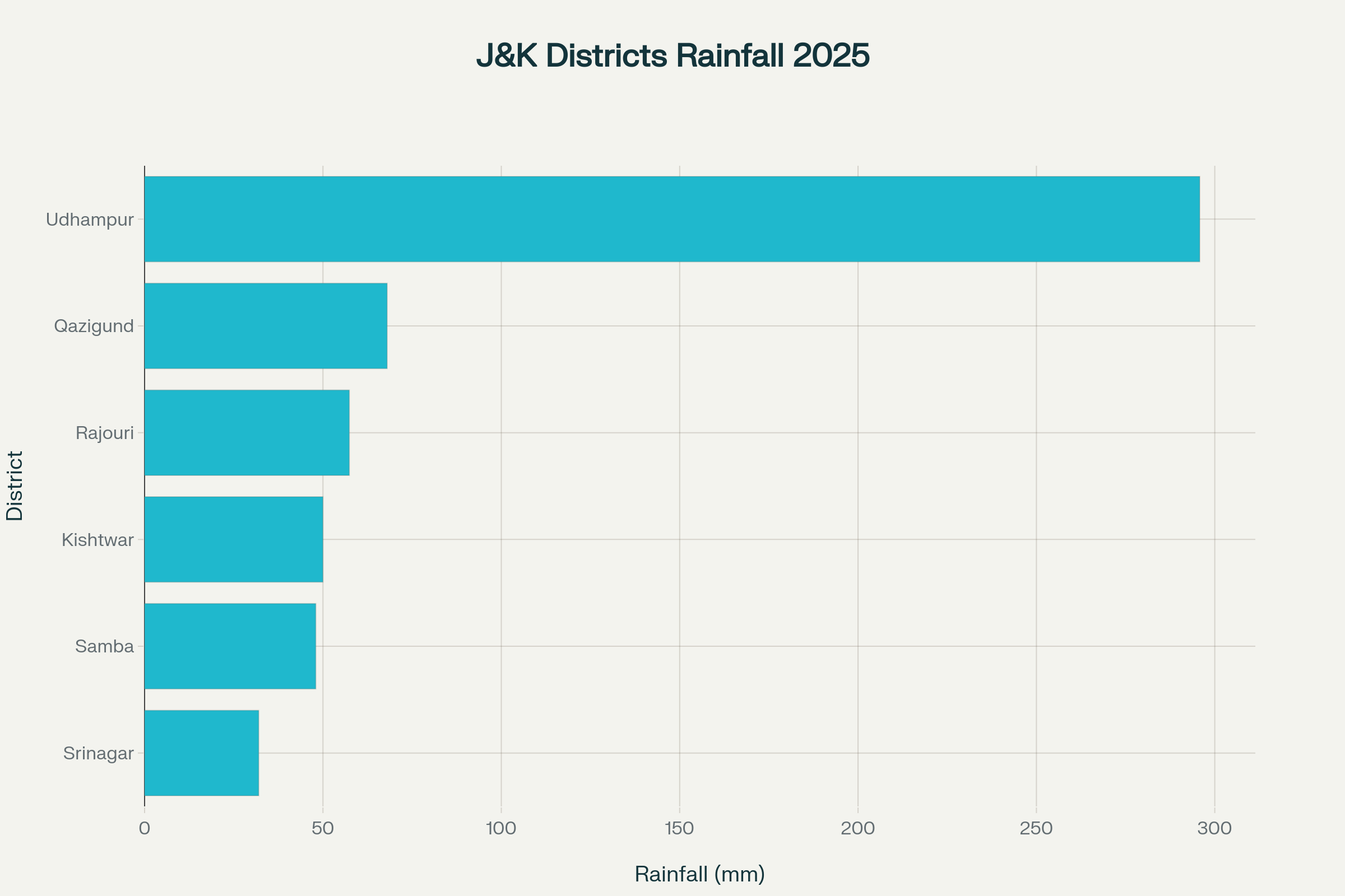
- India Meteorological Department recorded highest 24-hour rainfall at Udhampur (295.8 mm) with additional alerts issued for continued thunderstorms
Initial Context
The Kashmir Valley experienced severe weather conditions on September 2, 2025, as heavy rainfall accompanied by thunderstorms left Srinagar streets submerged and brought widespread flooding and chaos to the city and surrounding districts. The intense precipitation led to significant waterlogging across major roadways, forcing commuters and businesses to navigate through flooded streets while emergency services worked to manage the escalating situation.
The India Meteorological Department (IMD) reported heavy rainfall totaling 295.8 mm at Udhampur, marking one of the most significant precipitation events that contributed to Srinagar streets submerged conditions across the region. This extreme weather pattern resulted in immediate disruptions to daily life, with the meteorological center issuing warnings for continued heavy and intense showers accompanied by thunderstorms, lightning, and gusty winds across many parts of Srinagar, Ganderbal, and Budgam districts.
Areas particularly affected where Srinagar streets submerged included critical transportation hubs such as Residency Road, TRC Chowk, and Dal Gate, where waterlogging created substantial inconvenience for both pedestrians and vehicular traffic. The situation prompted authorities to implement emergency measures while monitoring rising water levels in major rivers and streams throughout the Kashmir Valley.
Flood Impact Assessment and Water Level Crisis
The heavy rainfall that left Srinagar streets submerged triggered a critical water level crisis across Kashmir’s river systems, with the Jhelum River breaching danger marks at multiple monitoring stations. According to official data from Jammu and Kashmir’s Irrigation and Flood Control department, the Jhelum River reached 25.51 feet at Sangam in South Kashmir’s Bijbehara, significantly exceeding the flood alert level of 21 feet and crossing the danger mark of 25 feet.
| Location | Current Water Level | Flood Alert Level | Danger Level | Status |
|---|---|---|---|---|
| Sangam (Jhelum) | 25.51 feet | 21 feet | 25 feet | Above danger level |
| Pampore | 5.19 meters | 4.5 meters | 5 meters | Above danger level |
| Vishow Stream | 11.20 meters | 7.75 meters | 8.50 meters | Critically high |
| Chenab River | 43.5 feet | 42 feet | 44 feet | Above evacuation level |
Water level monitoring revealed alarming statistics as Srinagar streets submerged conditions continued to worsen:
- Pampore station recorded water levels at 5.19 meters against the danger level of 5 meters and flood alert threshold of 4.5 meters
- Vishow stream at Khudwani rose dramatically to 11.20 meters, far above the flood alert level of 7.75 meters and damage mark of 8.50 meters
- Chenab River in Jammu reached 43.5 feet, approximately 1.5 feet above the evacuation level
The Doodhganga canal, originating from upper reaches of Budgam and flowing through Srinagar, experienced dangerously high water levels that contributed to Srinagar streets submerged conditions, forcing administrative authorities to divert water through the flood spill channel. Dal Lake, with its water holding capacity of 15.45 million cubic meters, served as a crucial buffer system during this crisis, helping to manage excess water flow from the precipitation event.
Rainfall Amounts in Jammu and Kashmir Districts, 2025
Infrastructure Impact and Emergency Response
The conditions that left Srinagar streets submerged resulted in widespread infrastructure disruptions across Jammu and Kashmir, severely affecting transportation networks and essential services. The Srinagar-Jammu national highway (NH-44) was completely closed for all vehicular traffic due to landslides, shooting stones, and extensive waterlogging at multiple locations caused by the intense precipitation.
Rail services faced significant interruptions as Srinagar streets submerged impact extended to railway infrastructure. Northern Railways suspended shuttle services for four trains between Jammu and Katra, while trains from New Delhi to Katra were short-terminated due to tracks being submerged underwater. Emergency transportation arrangements included seven special trains operating over four days, successfully evacuating 5,784 stranded passengers from flood-affected areas.
Educational institutions across Kashmir division remained closed as a precautionary measure following the weather event that left Srinagar streets submerged. Chief Minister Omar Abdullah directed his administration to maintain high alert status, intensify ground response capabilities, and ensure timely evacuation procedures from critical areas. The emergency response involved deployment of 17 NDRF teams, 23 Army columns, and Indian Air Force helicopters to assist in rescue and relief operations, with over 5,000 people evacuated to safer locations.
Power infrastructure suffered extensive damage from the flooding that left Srinagar streets submerged, with electricity supply disrupted across several areas of South and Central Kashmir. The combination of waterlogged streets and power outages created additional challenges for residents attempting to navigate the flood-affected areas where Srinagar streets submerged conditions persisted.
Meteorological Analysis and Forecast Patterns
The India Meteorological Department’s comprehensive analysis revealed that the weather event causing Srinagar streets submerged was part of a larger weather system affecting the entire northern Indian region. Official meteorological data indicated widespread moderate to heavy rain with isolated extremely heavy rainfall across Jammu and Kashmir, with temperature patterns showing significant variations from normal conditions.
Temperature anomalies during the period when Srinagar streets submerged included:
- Maximum day temperatures remained 4-9°C below normal in Kashmir Division
- Jammu Division experienced temperatures 8-13°C below normal
- Minimum night temperatures were 1-2°C below normal in Kashmir and 2-3°C below normal in Jammu
The meteorological forecast following the event that left Srinagar streets submerged predicted continued weather instability with widespread light to moderate rain and thunderstorms expected, along with isolated heavy rain over the next 24 hours. The IMD issued specific warnings for moderate to high flash flood risk across vulnerable areas, emphasizing the need for continued vigilance and preparedness measures.
Weather monitoring stations recorded varying rainfall amounts across different districts during the period when Srinagar streets submerged, with notable measurements including Srinagar (32 mm), Samba (48 mm), Kishtwar (50 mm), Rajouri (57.4 mm), and Qazigund (68 mm) during the critical 24-hour period. These measurements demonstrated the widespread nature of the precipitation event and its varying intensity across different geographical locations.
Closing Assessment
The September 2025 weather event that left Srinagar streets submerged represents a significant meteorological phenomenon that tested the region’s disaster preparedness and response capabilities. While the immediate crisis highlighted vulnerabilities in infrastructure and urban drainage systems, the coordinated emergency response involving multiple agencies demonstrated effective crisis management protocols. The event serves as a crucial reminder of the region’s susceptibility to extreme weather patterns and the ongoing need for comprehensive flood management strategies.
The conditions that caused Srinagar streets submerged extended beyond immediate flooding concerns, raising questions about long-term infrastructure resilience and climate adaptation measures. With Dal Lake’s substantial water holding capacity and the flood spill channel system providing critical flood mitigation, the event underscored the importance of maintaining and upgrading existing water management infrastructure to handle increasingly intense precipitation events. The situation where Srinagar streets submerged demonstrated both the challenges and the resilience of Kashmir Valley’s flood management systems in responding to extreme weather events.